Thinking spatially – balloon exercise helps students perceive time/space relationships

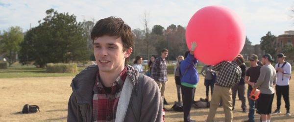
As part of a geography class on spatial thinking, a team of UNC Charlotte students launched a balloon outfitted with a camera to take aerial photographs of the campus. Later, they pieced the images together to form a map.
The students capitalized on blue skies with scattered clouds as they worked together to prepare the giant red balloon for liftoff. It takes six of them to hold the balloon and fill it with air, before they guide the orb to an open field near the main campus entrance. There, teaching assistant Adam Griffith donned leather gloves, grasped the sturdy 1,000-foot string before the team released the balloon.
Students faced the sky, shading their eyes from the sun, as they watched their creation take flight.
“One of the main objectives of this course is for students to cultivate a spatial thinking habit of mind,” said Elizabeth Delmelle, assistant professor in the Department of Geography and Earth Sciences, who teaches the class.
Using the lab exercise, the scholars gained hands-on experience that expanded their understanding of the concept, which offers a geographic perspective on how objects, processes and phenomena relate to each other in time and space. Individuals use this habit of mind when setting the table for dinner, packing a suitcase, reading a map or parking a car in a parallel space, for example.
“Geospatial technologies — such as maps, remote sensing imagery, GPS and other tools — are used with spatial thinking to address real-world problems,” Delmelle stated. “These technologies enable us to visualize and quantify spatial relationships in a concrete way.”
On this particular day, the students retrieved the tethered balloon and detached the camera. Then, it was time to sort through the photos collected and see what images could be pieced together to create a map.
“In class, we talk about clues used to identify features from above, such as the texture, shape, size, situation, and association of features,” Delmelle said. The balloon mapping exercise helps students understand scale and resolution, which are primary spatial thinking components. They also better understand how maps are created.
“As products such as Google Earth and Google Maps make remote sensing and mapping technology more freely available to everyone, it is important to have an understanding of what exactly these maps mean and how they can be used appropriately,” Delmelle stated.
While Google Earth and Google Maps now offer free access to images, the photographs often are not current.
“Google Earth photographs or other freely available imagery are representative of one single snapshot in time, often several years old,” Delmelle said. “If we wish to have more up-to-date images, we need to either take our own or purchase them from private companies.”
Using real-time images allows people to see what is occurring with a degree of immediacy.
“This is especially important for monitoring environmental disasters, for example,” said Delmelle. “Adam gives an example of his work in mapping the Deepwater Horizon oil spill a few years ago off the coast of Louisiana. In order to quantify the extent of the problem, we need real-time, up-to-date imagery to see how it has spread, where to, and what it might impact. These are all inquiries directly tied to our definition of spatial thinking.”